The Northern Antiquarian Forum

Would you like to react to this message? Create an account in a few clicks or log in to continue.
The Northern Antiquarian Forum

Archaeology, folklore & myth of Britain's pre-christian sites & heritage: stone circles, holy wells, maypoles, tombs, archaic cosmologies and human consciousness. Everyone welcome - even Southerners!


5 posters

    old stone markings, like a map

    avatar
    ajackson


    Join date : 2011-09-11

    old stone markings, like a map Empty old stone markings, like a map

    Post  ajackson Sun Sep 11, 2011 1:36 pm

    Hi all
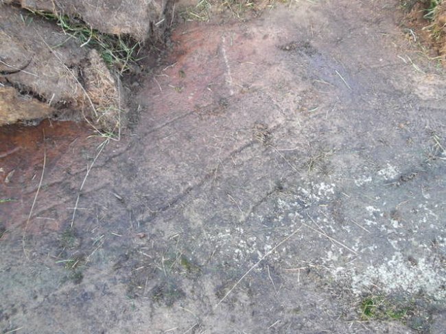
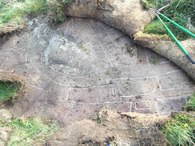
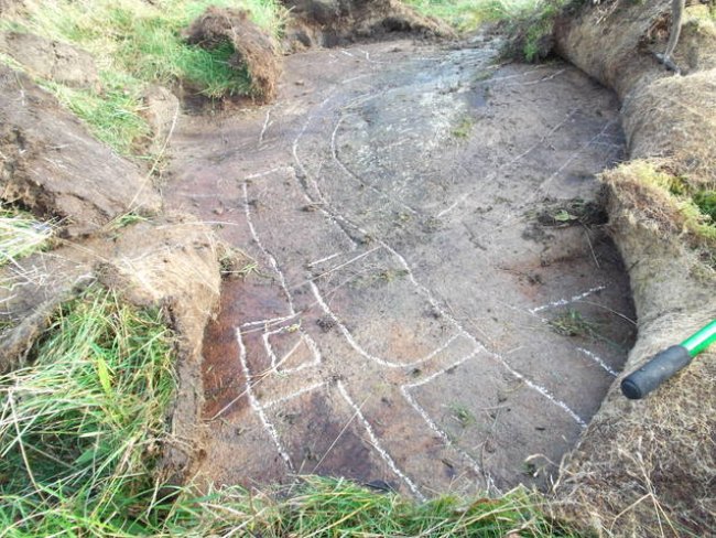
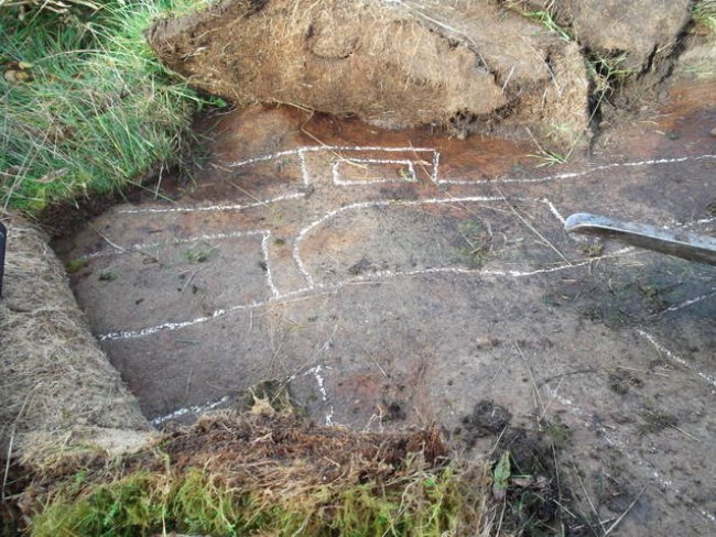
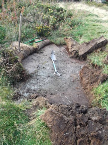
    As a new member to this site forwarded from a post by Keighley local history group, i am looking for any info on a place i played as a kid. On a place just known as the cragg in Long Lee,just off Moss carr rd Keighley,there is a very clear what looks like a map, recently i went looking for it again. Although it is well overgrown now it is still visible in one place, and when the top sod is peeled back it is still very clear. There are mentions of roman roads, druid paths and pack horse routs in the area, but there is no deffinate information these carvings, and no one i have talked to knows anything about them.
    CAN ANYBODY TELL ME ANYTHING ??????
    Andrew Jackson
    Sunbright57
    Sunbright57


    Join date : 2011-02-10
    Age : 67
    Location : Nelson - the one in Lancashire sorry to say!

    old stone markings, like a map Empty Re: old stone markings, like a map

    Post  Sunbright57 Sun Sep 11, 2011 2:01 pm

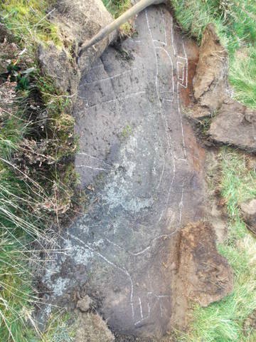
    Andrew has asked me to put these photos of 'The Map Stone' near Keighley on here for him. Please see the comments Andrew has added below.

    old stone markings, like a map Map_st10

    old stone markings, like a map Map_st11

    old stone markings, like a map Map_st12

    old stone markings, like a map Map_st13

    old stone markings, like a map Map_st14

    old stone markings, like a map Map_st15

    old stone markings, like a map Map_st16

    old stone markings, like a map Map_st17

    See comments below for location and grid reference etc.


    Last edited by Sunbright57 on Sat Sep 17, 2011 2:53 pm; edited 1 time in total
    Paulus
    Paulus


    Join date : 2009-08-20
    Location : Yorkshire

    old stone markings, like a map Empty Re: old stone markings, like a map

    Post  Paulus Sun Sep 11, 2011 2:20 pm

    Hi Andrew!

    ajackson wrote:As a new member to this site forwarded from a post by Keighley local history group, i am looking for any info on a place i played as a kid. On a place just known as the cragg in Long Lee,just off Moss carr rd Keighley,there is a very clear what looks like a map, recently i went looking for it again. Although it is well overgrown now it is still visible in one place, and when the top sod is peeled back it is still very clear. There are mentions of roman roads, druid paths and pack horse routs in the area, but there is no deffinate information these carvings, and no one i have talked to knows anything about them. CAN ANYBODY TELL ME ANYTHING ??????

    Can you give us a grid-ref to the place? Or a multimap / bingmap link (with the place in the centre of the page so we know the exact spot)? What are the carvings exactly? What's on 'em?

    Cheers - Paul
    avatar
    ajackson


    Join date : 2011-09-11

    old stone markings, like a map Empty Re: old stone markings, like a map

    Post  ajackson Sun Sep 11, 2011 3:42 pm

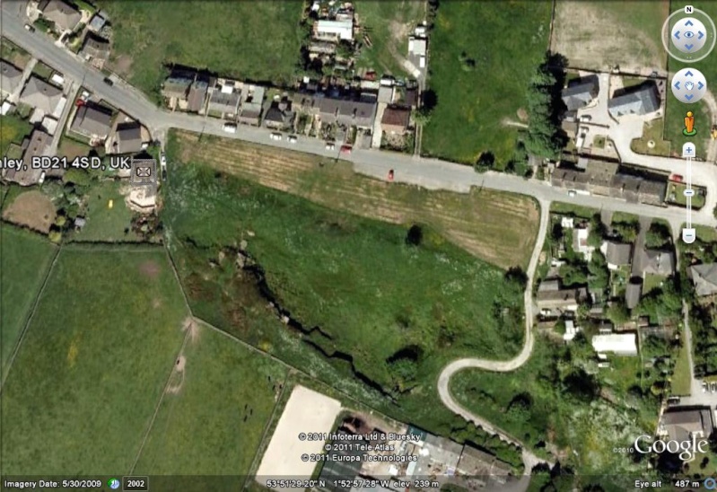
    best i can do for the momment is give you these details as i cant post a url for the fisrt seven days.these are as good as i can get for a grid ref 53deg 51,28.28"N 1deg52'59.43"W ELV 241MTR Or just put moss carr rd long lee keighley into google earth, look for the red car n the small lay by, to the right is a small S bend in the track rd, the crg itself is between the red car snd the large farm buildings. If i get time this weekend, i will try and uncover a bit moor, and photgraph it. Is there a way of putting a photo on here ????
    Paulus
    Paulus


    Join date : 2009-08-20
    Location : Yorkshire

    old stone markings, like a map Empty Re: old stone markings, like a map

    Post  Paulus Sun Sep 11, 2011 3:55 pm

    ajackson wrote:best i can do for the momment is give you these details as i cant post a url for the fisrt seven days.these are as good as i can get for a grid ref 53deg 51,28.28"N 1deg52'59.43"W ELV 241MTR Or just put moss carr rd long lee keighley into google earth, look for the red car n the small lay by, to the right is a small S bend in the track rd, the crg itself is between the red car snd the large farm buildings.

    I'll give it a look later Andy. I'm away for the next 2 days, but back to normal Wednesday.

    ajackson wrote:If i get time this weekend, i will try and uncover a bit moor, and photgraph it. Is there a way of putting a photo on here ????

    A photo would be good. If you wanna host an image, hover y' cursor over the symbols above where one says 'Host an image' and link it to your source, then upload and copy & paste the link it generates onto your reply. Mess about with it a bit. You'll work it out! Wink (keep previewing your reply until you gerrit right - that's wot I did!)

    All the best - Paul
    QDanT
    QDanT


    Join date : 2011-05-29
    Location : Earby used to be in Yorkshire

    old stone markings, like a map Empty Map and sat. photo's

    Post  QDanT Mon Sep 12, 2011 7:00 am

    Hi Andrew, if your not a member of, join photobucket http://photobucket.com/ sign in and upload your photo's to it, if you then hover your mouse pointer over them it will give a code in a drop down box, copy this and paste it into your message and as Paulus says check in pre-view. Is the well still there ? how about a photo ?

    old stone markings, like a map Mosscarrmap

    old stone markings, like a map Mosscarrrd1

    old stone markings, like a map Mosscarrrd2

    I'll keep these on here for a couple of days then delete them as they take up my bandwidth allowance, if you want them on TNA as yours right click, save as, and post to your photobucket then you can post them back onto this thread
    cheers Danny
    avatar
    ajackson


    Join date : 2011-09-11

    old stone markings, like a map Empty Re: old stone markings, like a map

    Post  ajackson Mon Sep 12, 2011 3:00 pm

    the photos and maps are spot on, although the the well on the map was just a boggy patch that i can remember. I havr tried posting a photo, but as a new member i cant post any for seven days
    Sunbright57
    Sunbright57


    Join date : 2011-02-10
    Age : 67
    Location : Nelson - the one in Lancashire sorry to say!

    old stone markings, like a map Empty Re: old stone markings, like a map

    Post  Sunbright57 Mon Sep 12, 2011 3:46 pm

    Ok Andrew, your photos are on now (see above). Ray.old stone markings, like a map 897440471
    avatar
    ajackson


    Join date : 2011-09-11

    old stone markings, like a map Empty Re: old stone markings, like a map

    Post  ajackson Sat Sep 17, 2011 3:13 pm

    cheers Ray you have been a great help with this
    avatar
    ajackson


    Join date : 2011-09-11

    old stone markings, like a map Empty Re: old stone markings, like a map

    Post  ajackson Sat Sep 17, 2011 3:23 pm

    I have known this place for most of my 48 yrs, and it had been there well before that. i know that this is just a fraction of what is there, but more skilful people than i would have to uncover it, but i would be only too glad to offer any assistance to anybody willing to take a deeper look at it. As far as i am aware, this is open common land. This is getting to be an itch i cant scratch
    Sunbright57
    Sunbright57


    Join date : 2011-02-10
    Age : 67
    Location : Nelson - the one in Lancashire sorry to say!

    old stone markings, like a map Empty Re: old stone markings, like a map

    Post  Sunbright57 Sat Sep 17, 2011 3:52 pm

    I know the feeling, Andrew. Something you want to get to the bottom of - so to speak. When Paul gets back, after the weekend, he might be able to help you more than I can. Good luck in your quest.old stone markings, like a map 2272988760
    avatar
    ajackson


    Join date : 2011-09-11

    old stone markings, like a map Empty image map

    Post  ajackson Sun Sep 18, 2011 3:52 pm

    old stone markings, like a map Moss_c11
    image map of Moss Carr Cragg, Long Lee Keighley, location of the stone carvings. From the road, the carvings are on the top of the cragg, from comments posted on facebook page, you know you lived in keighley when..... nobody has any real idea about them the best guess is that they are old but not aincent, and that the site is an old quarrie
    avatar
    ajackson


    Join date : 2011-09-11

    old stone markings, like a map Empty Re: old stone markings, like a map

    Post  ajackson Sun Sep 25, 2011 5:03 am

    with the assistance of the Keighley local hitory groups Andy Wade, the photos have been passed to archiologists at Bradford uni, and if anything comes from this i will pot it on here. But please feel free to add to the mystery
    Sunbright57
    Sunbright57


    Join date : 2011-02-10
    Age : 67
    Location : Nelson - the one in Lancashire sorry to say!

    old stone markings, like a map Empty Re: old stone markings, like a map

    Post  Sunbright57 Sun Sep 25, 2011 1:20 pm

    Probably the best thing to do Andrew. Let us just hope they DO take notice of these carvings and not just ignore them as old stone markings, like a map 897440471 so often happens.
    Paulus
    Paulus


    Join date : 2009-08-20
    Location : Yorkshire

    old stone markings, like a map Empty Re: old stone markings, like a map

    Post  Paulus Mon Sep 26, 2011 11:26 am

    Hi Andy -

    Soz aboutt he delay gerrin back to you. Been pretty busy. Any chance we could meet-up sometime early next week so you can take me along to see this curious-looking 'road map'? I aint seen a road-map etched onto stone before. It'd be good to work out which roads it represents.

    Cheers - Paul
    avatar
    ajackson


    Join date : 2011-09-11

    old stone markings, like a map Empty Re: old stone markings, like a map

    Post  ajackson Mon Sep 26, 2011 2:15 pm

    Hi Paul
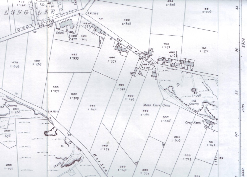
    It would be great to meet up soon best i can manage is the weekend due to work. Sat/sun pm are best for me. other than that, i have a week off end of october. just to let you know the area of the map tht is uncovered is only small about 8, by 3, but there is still alot under the top sod. I have attached a map from 1919 which shows the cragg, and there is a clearly deffined path / road across the top of the cragg. Some of the people from the Keighley local history group have said that there are civil war links to the area, weather this is a clue or not i dont know, but the concensus of opinion is that the carvings are old, but not aincient. please let me know whats best for you for meating up
    Yours
    Andrew Jackson
    old stone markings, like a map Long_l10
    Andy Wade
    Andy Wade


    Join date : 2011-09-27

    old stone markings, like a map Empty Long Lee (Keighley) stone inscriptions

    Post  Andy Wade Tue Sep 27, 2011 8:33 am

    Hi Everyone,
    First post on here and it's on something quite exciting (well I reckon so anyway). I visited these stone markings today and took some more pictures, the extent of the inscriptions could be quite large.
    My thoughts on them as an amateur historian (and over 30 years in the building trade):
    They were made with metal tools and appear well incised and clear, although they may have been covered for many years by a fibrous mat of undergrowth.
    There are some clearly defined pictographic shapes and they look like there is a cartographic element to them, with what appears to be buildings and roads or rivers marked (and even what appears to be a bridge).
    They aren't simple drawings and whoever did them was either just being mischievous or they did this for a very good reason. Either way they had a lot of time on their hands.
    The 'crag' is an old disused quarry so there's a small possibilty that they are of the same era, and one of the quarrymen did this. On another rock nearby there are also what appears to be two separate series of boxes in rows of five so I'm wondering if these were used for counting or perhaps a game?
    Rumour has it that a Roman Road passed near here and the Fairfax Entrenchment at St Ives Estate (English Civil War period) is only half a mile away. There's certainly a bit of history about these parts.
    I emailed a set of pictures to a friend who works at Bradford University Archaeology Department so we'll see if anyone comes back from that. Another friend who is a qualified archaeologist has just agreed to go up there with me and have a look at the inscriptions. It's not his speciality but he says he'd like to take a look.
    I think what's needed is to establish who owns the land to make sure we're ok digging the turf and heather back and we could do with someone who has an inkling to help record what's there. Only when we've established the extent of the markings will we have an idea of what they mean. Or not. Very Happy
    Paulus
    Paulus


    Join date : 2009-08-20
    Location : Yorkshire

    old stone markings, like a map Empty Re: old stone markings, like a map

    Post  Paulus Thu Sep 29, 2011 3:54 pm

    Hi Andy -

    ajackson wrote:It would be great to meet up soon best i can manage is the weekend due to work. Sat/sun pm are best for me.

    OK. Sunday afternoon alright? 1pm-ish? I'll walk up from where I live at Bracken Bank, which should take half-hour. I could meet you at the disused quarry-bit itself, off Moss Carr Road if y' like?

    Cheers - Paul
    Paulus
    Paulus


    Join date : 2009-08-20
    Location : Yorkshire

    old stone markings, like a map Empty Re: old stone markings, like a map

    Post  Paulus Thu Sep 29, 2011 3:57 pm

    Hi Andy (another one!) -

    Andy Wade wrote:My thoughts on them as an amateur historian (and over 30 years in the building trade):
    They were made with metal tools and appear well incised and clear, although they may have been covered for many years by a fibrous mat of undergrowth.
    There are some clearly defined pictographic shapes and they look like there is a cartographic element to them, with what appears to be buildings and roads or rivers marked (and even what appears to be a bridge).
    They aren't simple drawings and whoever did them was either just being mischievous or they did this for a very good reason. Either way they had a lot of time on their hands.
    The 'crag' is an old disused quarry so there's a small possibilty that they are of the same era, and one of the quarrymen did this.

    Yep - I'm with you all the way on this one! They've got a distinct 'Victorian' or slighly earlier look to them. But intriguing nonetheless. If y' fancy meeting up there, this Sunday around 1pm, twouldst be good! Cool

    Cheers - Paul
    avatar
    ajackson


    Join date : 2011-09-11

    old stone markings, like a map Empty Re: old stone markings, like a map

    Post  ajackson Thu Sep 29, 2011 10:32 pm

    Hi Paul, i can make 1 o,clock sunday, i could give you a lift or walk up with you i only live on Queens rd. meet you at the cross rds ingrow ln and Queens rd if you want
    Andy Wade
    Andy Wade


    Join date : 2011-09-27

    old stone markings, like a map Empty Re: old stone markings, like a map

    Post  Andy Wade Fri Sep 30, 2011 12:23 am

    Can't make Sunday I'm afraid, got some Aussie relatives coming over for a day on the Keighley and Worth Valley railway.
    Good luck!

    I might try for the Saturday after, when an archaeologist friend says would like to take a look at them.
    avatar
    ajackson


    Join date : 2011-09-11

    old stone markings, like a map Empty Re: old stone markings, like a map

    Post  ajackson Sat Oct 01, 2011 4:46 pm

    Game on, can make that what time ??? let me know
    found this on another web page

    From Ancient Bingley by J.Horsfall-Turner, 1898.

    "Upon the top of Harden Moor, not far from the above mentioned way, was shewn me by Benjamin Ferrand, Esquire, another Skirt of Stones much less than the two former, and nigh it a row of stones placed in a line nigh two hundred paces in length, but few of them appear above two feet above the heath, and some lie hid under it. That these stones were placed here by design, no person can doubt ; but for what end I cannot conjecture".

    "Burley, others at Pendle, indicates the burial place of a chieftain. Harden Cat Stones is enclosed on three sides by a considerable bank of earth and the ground bears traces of having been ploughed. This considerable entrenchment or camp is a marked feature of the map, but bears now a more modern name, Fairfax Entrenchment, though it is much more ancient than Fairfax's time".

    ". It is Druids Altar. quite likely that the Druid rocks are not misnamed, considering the rock-markings, circles of stones, burialmounds, carneddes, (" skirtful or apronful of stones," a name given to them not only on Burley and Harden Moors, but at Ecclesfield, Pendle, and other places,) canoes, flints, hammer-heads, arrow-heads, found in abundance on Ilkley, Baildon, Burley, Gilstead and other West Riding Moors".

    My only passion is for the rock art and megalithic stones this area, most of which are being destroyed before my eyes and which I am powerless to prevent. I see barrows being bulldozed and rock art quarried away every day and it tears me to bits If only some of them were recognised, people would protect them, but as they are not mentioned in that one book, they will be lost to to the future.
    Paulus
    Paulus


    Join date : 2009-08-20
    Location : Yorkshire

    old stone markings, like a map Empty Re: old stone markings, like a map

    Post  Paulus Sat Oct 01, 2011 4:55 pm

    ajackson wrote:Hi Paul, i can make 1 o,clock sunday, i could give you a lift or walk up with you i only live on Queens rd. meet you at the cross rds ingrow ln and Queens rd if you want

    OK Andy! See y' there in a few hours! Cool (by the school I assume?)

    Cheers - Paul
    avatar
    ajackson


    Join date : 2011-09-11

    old stone markings, like a map Empty Re: old stone markings, like a map

    Post  ajackson Sun Oct 02, 2011 11:46 am

    Hi Paul
    no probs about today, i dont know how it fits in with you, but i work out of town, but i can be up there around 5:45 pm give or take a few mins any day of the week there should be enough daylight left. i have a theory brewing but nothing deffinate, i have a part copy of a 1894 map of the area to compar and contrast
    Paulus
    Paulus


    Join date : 2009-08-20
    Location : Yorkshire

    old stone markings, like a map Empty Re: old stone markings, like a map

    Post  Paulus Sun Oct 02, 2011 1:20 pm

    We wandered up & had a look earlier this afternoon. The carvings are very obviously cartographic in nature (the word 'SHOP' at one section helped! Smile ), and if representative of the local area, is post-1850. Late-Victorian to early 20th century by the look of things. One of the local house-owners came up & started chatting, saying he knew about these carvings as a child when he lived here, and that they stretch further out from the section of rock you or Andy exposed. Then John Webb arrived aswell (hoping for some cup-markings), who thought they were pretty recent too.

    The carving's intriguing though, inasmuch as distinct map-carvings like this, even from Victorian periods, are not common (though don't quote me on that, as that aint my period - and no doubt someone with a history in quarrying can show otherwise!). So we're gonna go back up later this week to have another chat with the locals, who themselves would love to know more, and clean & plot the site better. If parts of the 1894 map that you've got fit the carving, let us know - and mebbe see y' later in the week.

    Cheers - Paul

    Sponsored content


    old stone markings, like a map Empty Re: old stone markings, like a map

    Post  Sponsored content


      Current date/time is Fri Sep 13, 2024 8:34 pm