The Northern Antiquarian Forum

Would you like to react to this message? Create an account in a few clicks or log in to continue.
The Northern Antiquarian Forum

Archaeology, folklore & myth of Britain's pre-christian sites & heritage: stone circles, holy wells, maypoles, tombs, archaic cosmologies and human consciousness. Everyone welcome - even Southerners!


4 posters

    Archaeological Field Trips during the Spring & Summer

    lowergate
    lowergate


    Join date : 2010-11-01
    Age : 75
    Location : CLITHEROE

    Archaeological Field Trips during the Spring & Summer  Empty Archaeological Field Trips during the Spring & Summer

    Post  lowergate Fri Mar 23, 2012 2:49 pm

    Starting this Saturday (March 24) I will be running Archaeological Field Trips during the Spring & Summer months. This Saturday we will be looking at a stone circle and a number of tumulus burial mounds on Oswaldtwistle Moor. The highlight of the day will be looking at oak and birch trees that have been buried for over 4000 year by a build-up of 20ft. of blanket peat formation, exposed due to land slip. These trees would have been last seen in all their glory during the Bronze Age by the builders of the circle and Tumuli.

    If anyone you know or members of TNA wish to join these events they can Email/internal mail me for location and start times. There is no charge for these events.

    John Dixon
    QDanT
    QDanT


    Join date : 2011-05-29
    Location : Earby used to be in Yorkshire

    Archaeological Field Trips during the Spring & Summer  Empty Bollocks

    Post  QDanT Sun Mar 25, 2012 4:23 am

    Ok I e-mailed that night (Friday) to say I'd be up for it.
    NO REPLY !
    I packed haversack anyway and e-mailed again Saturday morning
    NO REPLY !
    At such short notice why didn't Mr. Dixon post start place and time ?
    and he had computer on Saturday morning because he posted on here !
    I went out Flint hunting anway
    cheers Danny
    lowergate
    lowergate


    Join date : 2010-11-01
    Age : 75
    Location : CLITHEROE

    Archaeological Field Trips during the Spring & Summer  Empty Rough report on field trip

    Post  lowergate Sun Mar 25, 2012 9:41 am


    OSWALDTWISTLE MOOR FIELD TRIP 24/03/12

    Conditions: Warm 17C, dry conditions underfoot, distant views obscured by heat haze.

    START: Oswaldtwistle Mills multiple retail outlet.

    Almost hidden away in this multiple retail complex is a superb local heritage centre displaying the history of Oswaldtwistle since prehistoric times. The centre was established by the local people of the town and supported by the complex owner. The section we came to view was the early pre-history illustrated ‘time line’, the sole work of local antiquarian Mr.Alan Ormerod.

    Here the early archaeology of Oswaldtwistle is laid out in great detail through the medium of maps, illustrations and artefacts. Among the artefacts are three Langdale stone axes found on the Moor along with samples of birch and oak found below the blanket peat covering of the Moor. Two stone circles are recorded along with numerous possible burial mounds with locations, illustrations and diagrams. Our interest was in Thirteen Stone Hill circle, Dry Hill tumulus and the birch and oak forest below the blanket peat, the latter being slowly exposed due to erosion and slippage.

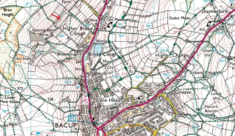
    Next, up to the moor with parking available in a small lay-by on the A677 below Elm Tree Farm (SD762 251).

    The farm track soon becomes a holloway/old turbury road leading over a saddle between the Moor and Thirteen Stone Hill to Haslingden Grain. Before gaining the saddle we struck off to the SW following the mediaeval boundary ditch between Oswaldtwistle and Haslingden. A mile ahead the distinct form of Dry Hill comes into view:

    Until the Countryside & Rights of Way Act 2000, Oswaldtwistle Moor was private land with no public access other than two paths that crossed the moor N/S at either end. Today it is available for access on foot.

    Oswaldtwistle Moor stands at c.340M ASL and is covered by a blanket peat bog some 3-4M in depth. During the 18th & 19th century’s drainage of the moor was undertaken to improve the land for sheep grazing but proved unsuccessful leaving the peat blanket formation virtually intact. Below the blanket peat lies a Neolithic/Bronze Age landscape from a time of the first forest clearances on the uplands of the Pennines that later, as the climate became cooler and wetter, led to a gradual leaching of soil nutrients, sphagnum moss and cotton grass colonized the uplands resulting in the blanket of peat bog which is so widespread today.

    At the time of writing this unique landscape is about to rapidly change in a most dramatic way. For political none-economic reasons an industrial scale wind generating plant (the word ‘farm’ is inappropriate, a political whim or fancy, sounds nice and ‘environmental’, ‘green and clean’ like ‘Windowleen’) is under construction on the moor: Huge ‘Transformer’ type excavation machines are removing the peat and sub-soil covering down to the bedrock, platforms are being erected, cable conduits laid and access roads to each generating station being laid out. The result of this industrialization of the landscape will in a few years time leave the moor a denuded ‘moonscape’ as has happened on the high fells of the Bowland watershed due to industrial water extraction methods.

    So we take a last look at a landscape that over the next few weeks will be gone forever.

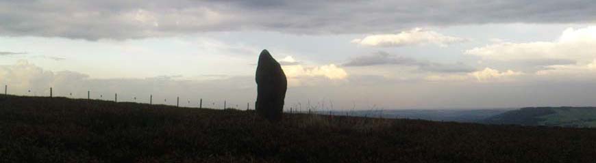
    Dry Hill (SD 748 243 is a grassy dome rising above the peat blanket to a height above 6M. Close inspection reveals it to be of stone construction built on the sub-soil below the peat. Without a doubt the tumulus is man-made and has been ascribed to the Bronze Age period on the SMR. If this is indeed a burial mound it must be the largest one ever recorded in Lancashire and must be seen as an important structure for the time. The summit of the mound commands extensive views over Blackburn and Hyndburn – the final resting place of some important person or family. Dry Hill was erected as a landscape statement and commands attention.

    Taking a last look at this soon to be lost landscape we turned south and made our way over to the higher watershed reaches of Deep Clough. Rapid erosion of the peat blanket here (SD 750 239), sub-soil section seen to be about 2ft. in depth, and silver birch trees everywhere! Trees that last saw the light of day some 3500 years ago, an amazing sight. Within minutes we came upon the stump and root of a large oak tree as in a good a condition as the day it was felled, again some 3500 years ago! We intend to return this coming week to see if we can discern and record any axe marks from when it was felled.

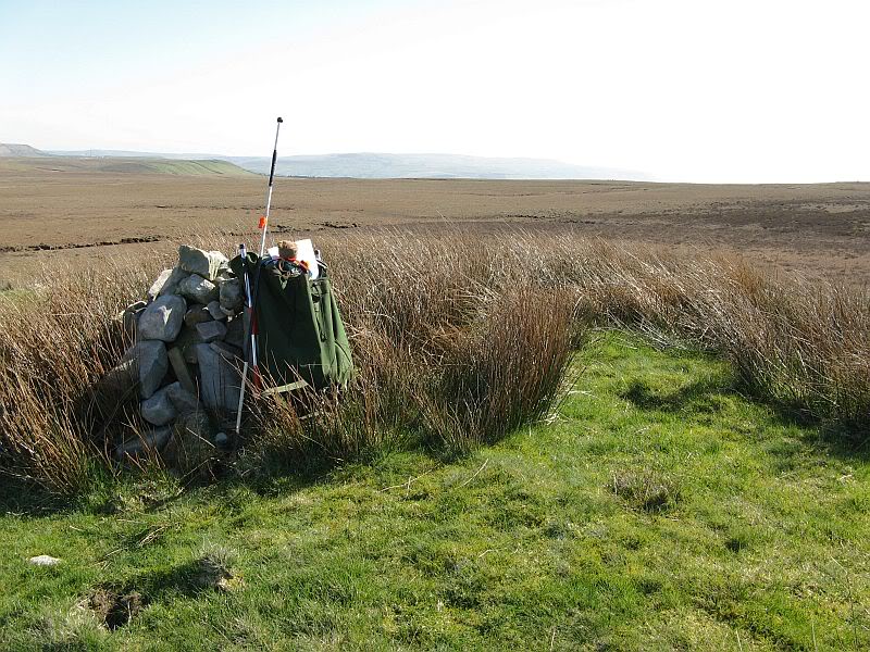
    On we went to summit of Thirteen Stone Hill where on the southern edge (SD 765
    242) we found thirteen stones. Yes, thirteen large stones, but to our eyes not a thirteen stone circle. GPS location of each stone then mapping is needed to determine the nature of this feature, be it natural or man-made. Nearby we noted the evidence of systematic peat cutting in the distant past – a peat-sled Holloway passes N to S just to the W of the 13 stones. Also noted near to the stones 3 small man-made ‘ponds’, circular with raised banks – purpose unknown.

    All in all a great day out for all.
    QDanT
    QDanT


    Join date : 2011-05-29
    Location : Earby used to be in Yorkshire

    Archaeological Field Trips during the Spring & Summer  Empty Been there got the T shirt

    Post  QDanT Tue Mar 27, 2012 4:39 pm

    lowergate wrote:
    If anyone you know or members of TNA wish to join these events they can Email/internal mail me for location and start times. There is no charge for these events.John Dixon

    Tried to PM but :- Information lowergate has chosen not to receive private messages.
    So sent e-mail, received an e-mail back from Mr D, Sat. night asking if I like to visit this week, replied yes (Sat. night) but have not heard any more, so I went and had a look Tuesday anyway

    Archaeological Field Trips during the Spring & Summer  38
    Dry Hill Tumulus
    Archaeological Field Trips during the Spring & Summer  18

    Archaeological Field Trips during the Spring & Summer  19

    more photo's on my Blog :- http://teddytourteas.blogspot.co.uk/2012/03/oswaldtwistle-moor.html
    cheers Danny
    Sunbright57
    Sunbright57


    Join date : 2011-02-10
    Age : 66
    Location : Nelson - the one in Lancashire sorry to say!

    Archaeological Field Trips during the Spring & Summer  Empty Re: Archaeological Field Trips during the Spring & Summer

    Post  Sunbright57 Wed Mar 28, 2012 1:13 pm

    You weren't too far off me Danny. I was up exploring dykes above Broadclough, Bacup. Lovely sunny day with a nice cooling breeze at times.
    QDanT
    QDanT


    Join date : 2011-05-29
    Location : Earby used to be in Yorkshire

    Archaeological Field Trips during the Spring & Summer  Empty Re: Archaeological Field Trips during the Spring & Summer

    Post  QDanT Wed Mar 28, 2012 3:42 pm

    Sunbright57 wrote:You weren't too far off me Danny. I was up exploring dykes above Broadclough, Bacup. Lovely sunny day with a nice cooling breeze at times.

    Hi Ray, didn't know you were into Lesbians ?

    did you find owt ? - cheers Danny


    Last edited by QDanT on Sat Mar 31, 2012 5:32 am; edited 1 time in total
    Sunbright57
    Sunbright57


    Join date : 2011-02-10
    Age : 66
    Location : Nelson - the one in Lancashire sorry to say!

    Archaeological Field Trips during the Spring & Summer  Empty Re: Archaeological Field Trips during the Spring & Summer

    Post  Sunbright57 Wed Mar 28, 2012 3:54 pm

    No not really, well? The Dykes are a bit off your map at the top right. They are not shown on the Os maps. Have just added a photo. sunny
    QDanT
    QDanT


    Join date : 2011-05-29
    Location : Earby used to be in Yorkshire

    Archaeological Field Trips during the Spring & Summer  Empty Re: Archaeological Field Trips during the Spring & Summer

    Post  QDanT Thu Mar 29, 2012 1:40 am

    Hi Ray I don't mind posting a map, but is there any chance of being more precise ? I've added the grid numbers and it's the number towards the East first then splitting the square into 10ths.The three numbers along with the second set going North the same way will mark a 100 yard square on the map. I've included the grid ref. for the 432 spot hight.
    If you want I can then incerease the map scale, go to old OS maps, or a satelite image

    Archaeological Field Trips during the Spring & Summer  Broadclough3

    cheers Danny
    Sunbright57
    Sunbright57


    Join date : 2011-02-10
    Age : 66
    Location : Nelson - the one in Lancashire sorry to say!

    Archaeological Field Trips during the Spring & Summer  Empty Re: Archaeological Field Trips during the Spring & Summer

    Post  Sunbright57 Thu Mar 29, 2012 10:28 am

    Apologies Danny, I think I said top right, that should be top (far) left above Dykes farm at Os co-ordinates SD.8635 2435. Don't know my right from left ! Yes, the dykes can be seen from an aerial view if you want to put one up you will need to zoom in a fair bit. But would be nice. Ray.
    Paulus
    Paulus


    Join date : 2009-08-20
    Location : Yorkshire

    Archaeological Field Trips during the Spring & Summer  Empty Re: Archaeological Field Trips during the Spring & Summer

    Post  Paulus Thu Mar 29, 2012 12:05 pm

    QDanT wrote:...Hi Ray, didn't know you were into Lesbians ?
    rollaboutlaughing

    Good to see you're still about Dan! If y' fancy a walkabout over Ilkley-way in a coupla weeks, we've found yet more cup&rings - and what truly looks like a collapsed stone circle, overgrown but easily accessible with a bitta un-lesbian prodding - it'd be good to meet up again. spot-on
    QDanT
    QDanT


    Join date : 2011-05-29
    Location : Earby used to be in Yorkshire

    Archaeological Field Trips during the Spring & Summer  Empty Lucky Bag

    Post  QDanT Thu Mar 29, 2012 12:44 pm

    Sunbright57 wrote:Apologies Danny, I think I said top right, that should be top (far) left above Dykes farm at Os co-ordinates SD.8635 2435. Don't know my right from left ! Yes, the dykes can be seen from an aerial view if you want to put one up you will need to zoom in a fair bit. But would be nice. Ray.

    Hi Ray I hope we can get there in the end, but the co-ordinates you give are already on the maps I posted. I've arrowed them in red this time, but do check back to the originals. When we get it right I'll delete all these as they eat up my bandwith

    Archaeological Field Trips during the Spring & Summer  Broadclough2-1


    Last edited by QDanT on Sat Mar 31, 2012 5:35 am; edited 3 times in total (Reason for editing : No point in eating bandwidth ! with non required maps)
    QDanT
    QDanT


    Join date : 2011-05-29
    Location : Earby used to be in Yorkshire

    Archaeological Field Trips during the Spring & Summer  Empty Prod - a - Lesbian

    Post  QDanT Thu Mar 29, 2012 12:55 pm

    Paulus wrote:
    QDanT wrote:...Hi Ray, didn't know you were into Lesbians ?
    rollaboutlaughing

    Good to see you're still about Dan! If y' fancy a walkabout over Ilkley-way in a coupla weeks, we've found yet more cup&rings - and what truly looks like a collapsed stone circle, overgrown but easily accessible with a bitta un-lesbian prodding - it'd be good to meet up again. spot-on

    Hi no prob's, have wine will travel, here's todays Tour, with a Flint !
    http://teddytourteas.blogspot.co.uk/2012/03/scrubbing-mill-chimmney-musbury-heights.html
    Archaeological Field Trips during the Spring & Summer  Bettergetdrunk
    cheers Danny
    Paulus
    Paulus


    Join date : 2009-08-20
    Location : Yorkshire

    Archaeological Field Trips during the Spring & Summer  Empty Re: Archaeological Field Trips during the Spring & Summer

    Post  Paulus Thu Mar 29, 2012 1:40 pm

    QDanT wrote:Hi no prob's, have wine will travel, here's todays Tour, with a Flint !
    http://teddytourteas.blogspot.co.uk/2012/03/scrubbing-mill-chimmney-musbury-heights.html
    Archaeological Field Trips during the Spring & Summer  Bettergetdrunk
    cheers Danny

    Yeahhh... I really like that! The endless wine doth poureth - have you been talking to Jesus again!? Rolling Eyes
    lowergate
    lowergate


    Join date : 2010-11-01
    Age : 75
    Location : CLITHEROE

    Archaeological Field Trips during the Spring & Summer  Empty OSWALDTWISTLE MOOR AUGUST FIELD TRIP

    Post  lowergate Tue Jul 10, 2012 11:08 pm

    OSWALDTWISTLE MOOR FIELD TRIP 12th August 2012

    10.30.am. Sunday 12th August 2012 - let me know here if anyone wishes to come. 'Meet Up' to be determined.

    Further Notes:

    I have now obtained a survey map of the original position of the stones on the summit of Thirteen Stone Hill (SD 766 242/PRN1096) and they indeed form a circle. With the help of a GPS we can determine the ones now that stand in their original position and those that have been moved along with the places they once stood – should be fun!

    Dry Hill Mound (SD 748 243 /PRN20309 is indeed a Late Neolithic/Early Bronze age mound. The barrow is made of stone which would have been available only after the original forest soil had been disrupted by agriculture and the surface lowered by deflation. Upon this high moor there is strong evidence from pollen analysis that the land was used for cultivation – a variety of weeds of cultivation including ribwort plantain (Plantago lanceolata) occurs.

    Birch and oak trees below the peat (watershed to the south of Dry Hill): The oak stumps may display the marks of stone (Langdale) axe felling – to be determined.

    john

    www.aussteigerpublications.com


    Last edited by lowergate on Mon Jul 16, 2012 6:38 am; edited 1 time in total
    lowergate
    lowergate


    Join date : 2010-11-01
    Age : 75
    Location : CLITHEROE

    Archaeological Field Trips during the Spring & Summer  Empty Re: Archaeological Field Trips during the Spring & Summer

    Post  lowergate Mon Jul 16, 2012 2:36 am


    THIRTEEN STONE HILL, OSWALDTWISTLE MOOR SD 766 242

    Location of stones, 1972 survey by M K Eckersall & Alan Ormrod.

    Co-ordinates are given from the North, clockwise:

    1) 376658.789 424285.374
    2) 376663.300 424281.872
    3) 376666.268 424270.505
    4) 376664.365 424265.294
    5) 376653.323 424260.415
    6) 376649.422 424260.018
    7) 376645.894 424262.455
    Cool 376641.691 424267.250
    9) 376640.415 424272.860
    10) 376639.794 424277.069
    11) 376641.610 424279.135
    12) 376643.203 424281.758
    13) 376650.609 424286.756

    The circle a diameter of 88ft./29 yds.


    Sponsored content


    Archaeological Field Trips during the Spring & Summer  Empty Re: Archaeological Field Trips during the Spring & Summer

    Post  Sponsored content


      Current date/time is Fri Apr 26, 2024 9:23 pm